
Zoom out and look at it
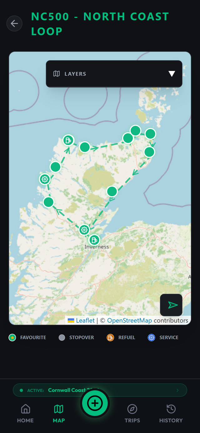
Open the map and pull back. Every stop you've logged sits there as a marker: the parkups, the campsites, the fuel stops, the ferry ports. After one season it's a scatter. After three years it's a shape: the west coast run you've done twice, the odd gap through mid-Wales you keep meaning to fill, the cluster along the Moray coast where the parkups turned out to be good.
That picture is the point. A logbook is useful one entry at a time, but a map shows you the whole thing at once, and it answers questions you didn't know you were asking. Why do we always end up in Northumberland? And somehow we've never once stopped between Carlisle and Glasgow.
Rain day on a site near Llangollen, awning dripping, nowhere to be. We spent half an hour zoomed out over two years of markers and noticed every trip bent south-west in the end. Booked the Scottish ferry that evening, mostly out of stubbornness.
Tap a marker, get the whole record
Each marker is a door into a full stop record. Tap one and a popup gives you the stop; open it and everything you logged is there. The date, the notes, the weather, what it cost, the noise and views scores, how level the pitch was. The map is the same logbook, arranged by where instead of when, rather than a separate feature bolted on the side.
Markers and popups are custom-built for the app rather than generic pins, so what you see on the map is your data, not clutter.
An exact pin, not a postcode
Every stop carries GPS coordinates, picked on the map or taken from where you're stood. A postcode covers half a hillside; a coordinate covers the three metres your wheels are on. That precision pays off in dull, important ways: finding the same wild spot again when the track looks different in the dark, knowing which end of a two-hundred-metre layby had the level ground, or reading a location straight off a stop record to a recovery driver who has never heard of the brown tourist sign you're parked past.
The same log, in date order
The map answers where. The history screen answers when. Every stop, service visit, fuel fill, toll and ferry lands in one timeline that reads in order, with most of a trip visible in a single scroll. Ten years of paper logbooks work the same way. This is that, minus the shelf.
It is also the screen that settles the argument about the campsite near Ullapool, the one with the view over Loch Broom and the shower block that ate pound coins. Was that 2024, or the year before? Scroll back and there's the entry: the date, the notes you wrote at the time, the weather you tagged, what it cost. Written down by someone with no stake in the argument, because that someone was you, on the day.
A full timeline gets long, which is rather the point, so you can narrow it to a single trip and open it back out to everything at once. And entries stay editable long after the fact, because logs written at 9pm in the rain are honest but not always complete. Fix the odometer typo. Add the note about the height barrier you only remembered at breakfast. Score the noise properly once you've slept through the Friday-night traffic, or not.
The places you'd go back to
Most stops are fine and forgettable. Then occasionally you get one that isn't: the quiet parkup above the beach with the level pitch and the phone signal, the aire with the free borne, the campsite where the warden waved you onto the hardstanding before the rain came. You say "we'll come back here" out loud, and eighteen months later you're squinting at the map going, was it this bay or the next one?
Favourites is where that sentence goes to be kept. Each one gets a type, because the reason you'd return differs:
- Parkup: the wild and informal spots
- Campsite: the paid pitches worth paying for again
- Aire: the continental staples
- Service: water, waste and cassette points you'll need on every pass through
That last one is the workhorse. Nobody gets sentimental about a service point, but knowing exactly where the reliable one is on your route through Normandy is worth more than any view.
A pin on its own tells you where. A favourite tells you what's there: the facilities list, plus your own notes in your own words. "Arrive before 4, fills up." "Borne takes coins only." "Left-hand end is the level bit." Detail you'd never get from a review site, because it was written by you, for you, in a van the same shape as yours, calibrated to your height and your tolerance for a dodgy track. Favourites sit on the same map as your stops, so planning a route north means dragging the map along the A9 and seeing what past-you already found.
Aire outside Boulogne, hammering rain, and the borne swallowed our last euro coin without dispensing a drop. The favourite we saved that night reads: "Water iffy: carry coins, or use the service point 6km south, free and works." Two years later, on the same run from the tunnel, that note saved past-us from doing it twice.
Sending someone the spot
You can share your GPS position with friends from the app, which covers the two situations where it matters. The useful one: telling the people meeting you where the gate actually is, rather than the village three miles away that the postcode points at. The other one: telling somebody at home where you are parked, on a night when that feels worth doing. Sharing needs a connection, being a message to another human, so it is the one part of this page that wants bars.
Built on OpenStreetMap
The map itself is OpenStreetMap, rendered with Leaflet. It's the mapping that most of the vanlife world already runs on, and it covers the single-track roads and back lanes that matter to a 7-metre vehicle better than most alternatives.
Map tiles are pictures downloaded from the internet, so like any map app it wants a connection to draw an area it has not seen before. Pull the region up while you still have bars and it behaves. The logging itself has no such need: a stop goes down in a glen with nothing on the meter and catches up when you do.
The long game
Ten stops on a map is a trip. Three hundred is a record of how you actually travel: where you linger, where you only ever pass through, which coasts you've worn a groove into. Every stop you log from the driver's seat tonight becomes a marker you'll tap in two years' time, trying to remember the name of that spot above the beach, and a line in the timeline that tells you what the night was actually like. If you are still deciding what is worth putting in each entry, the guide on what is worth writing down at a stop is the place to start, and before you save a wild one it is worth knowing where overnight parking is actually legal.
Drop your first pin this weekend
Stops become markers, markers become the map of everywhere you've slept, and the keepers get saved. Ten stops free. No ties.